Overview
Position Integrity TerrAvoid is a high-performance standards-based
software application designed to reduce Controlled Flight Into
Terrain (CFIT) accidents and save lives. Developed under military
contract and already a proven air safety asset to the military
community, TerrAvoid provides a visual depiction of surrounding
terrain using advanced high-resolution data.
Details
TerrAvoid was written for the Microsoft Windows family of operating
systems, yet its terrain manipulation algorithms have been used by
several aerospace and avionics manufactures in embedded avionics
systems. The primary terrain algorithms are portable to virtually
any platform and currently support high resolution military terrain
data, but can be easily adapted to support lower resolution terrain
data like Digital Elevation Models (DEM).
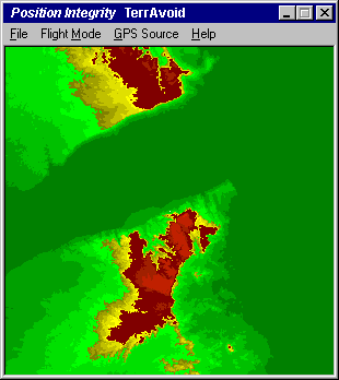
TerrAvoid constructs and updates a shaded relief map only the fly,
changing its colors dynamically based on your relative position to
the surrounding terrain, as determined by an attached GPS receiver.
The look-ahead distance will provide at least eight minutes of
terrain warning, an order of magnitude more than most commercial
ground proximity warning systems (GPWS) available today.
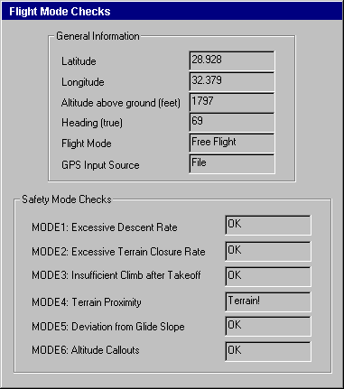
TerrAvoid also provides the Flight Mode Checks and Warning Mode
Checks specified by the Federal Aviation Administration for terrain
avoidance systems. TerrAvoid can be configured to display this
information simultaneously along side the map window.
Advanced Datasets
The Position Integrity development team is working in close proximity
with NASA's Jet Propulsion Laboratory and will be the first to
integrate the advanced terrain and obstacle datasets resulting from
the 2000 Shuttle Radar Topography Mission (STRM). This new dataset
will bring highly accurate terrain and obstacle information to the
general public at resolutions that were previously only available to
the military or classified government agencies.
For more information about Position Integrity TerrAvoid,
please contact us by
telephone or email.