
|
|
|
|
| Tailored Data Subscription Services | |
|
|
|
|
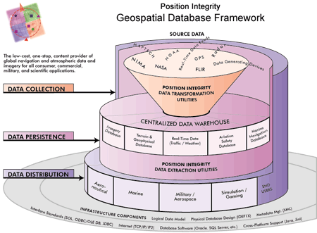
The Position Integrity Geospatial Database Framework (GDF) is the blueprint for our technology infrastructure and the basis for the creation, production, maintenance and distribution of the data products we offer. Position Integrity's primary objective is to continuously improve its global warehouse of navigational, atmospheric and geospatial data to benefit application developers, hardware manufacturers, and system integrators in the aviation and marine markets.
In contrast to our competitors whose current data offerings consist predominantly of standardized data products, often distributed in restrictive formats, the GDF enables us to supply both packaged and individually tailored data subscription services to meet the specific needs of virtually any customer. Where other data providers protect their intellectual rights by supplying their data in proprietary formats, we believe our ability to provide data in native formats specified by the client will enhance our strategic position as a data vendor. Our approach has caught on. Several major software vendors, avionics manufacturers, and system integrators are already receiving tailored subscriptions delivered in formats they designed that are native to their operating environment. For more information about our tailored data subscription services, please contact us by telephone or email. |
|
| Copyright © 1993-2026 Position Integrity, LLC |
